| With 2012 fast approaching, there has been a lot of speculation about the poles changing place or moving. While the possibility of a polar shift is quite possible, and appears to have happened in the past, another possibility needs to be considered.
There is strong evidence that the surface of our planet — the thin skin called the “crust” — has suddenly shifted in the past. While the Earth remained in its normal axis, this shift caused entire continents and oceans to move, changing climates and altering entire ecosystems and weather patterns.
We present the following information as proof of these past shifts and suggest that a similar event may be in store for Earth’s immediate future.
The Shifting Poles Theory
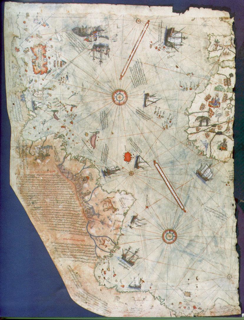
The “Shifting Poles Theory” was introduced by History Professor, Charles H. Hapgood, whose fascination with geography and ancient maps led to his re-discovery of the Piri Re’is Map [right click to enlarge].
 This hand drawn Turkish naval map had been gathering dust since the early 1500’s, its significance unrealized. On closer scrutiny, Hapgood observed evidence of spherical trigonometry and a detailed knowledge of global geography– including the coastline of Antarctica at a remote time, when it was free of ice. This hand drawn Turkish naval map had been gathering dust since the early 1500’s, its significance unrealized. On closer scrutiny, Hapgood observed evidence of spherical trigonometry and a detailed knowledge of global geography– including the coastline of Antarctica at a remote time, when it was free of ice.
The map had been drawn just a few years after Columbus visited the Americas. The cartographer, Admiral Piri Re’is, described his world map as having been drawn from “very old” reference maps. It appeared as if some ancient, forgotten civilization had risen to these capabilities, and then had disappeared. The identity of these ancient mariners begged to be discovered.
The most obvious place to look for such an old, yet advanced, civilization was in the famous accounts of the lost continent, Atlantis, described in somewhat vague, but realistic, commentary by the Greek historian, Plato.
Captain Jacques Cousteau concluded that Plato’s Atlantis was in the Mediterranean, near Greece. His underwater explorations found evidence of extensive maritime trading and skilled boat building, along with some artifacts dated to thousands of years B.C. But no vast metropolis was found. Scholars called attention to the utopian descriptions of Plato, who hinted that Atlantis was in the “ocean” and “beyond the pillars of Hercules,” known today as the Straight of Gibraltar. And so tradition eventually placed Atlantis somewhere on the bottom of the Atlantic Ocean. But where?
| More on the Peri Re’is Map Thought to be one of the earliest “world maps” to show the Americas, the map was originally used to bolster Turkish national pride. Early scholars suggested that it showed accurate latitudes of the South American and African coastlines – only 21 years after the voyages of Columbus! (And remember, Columbus did NOT discover North America – only the Caribbean!) Writing in Piri Re’is own hand described how he had made the map from a collection of ancient maps, supplemented by charts that were drawn by Columbus himself. This suggests that these ancient maps were also available to Columbus and could have been the basis of his daring expedition.
A copy of the map was presented to a diplomat in the U.S. government, where it remained a curious artifact for years. The true mysteries of of this map were eventually discovered by professor Charles H. Hapgood and revealed to the scientific community in his book, Maps of the Ancient Sea Kings.
During scrutiny of the map, Hapgood discovered a partial charting of Antarctica, made during a period when the coast was free of ice. This coastal structure, now covered again by ice, was subsequently verified by satellite radar scanning. Ice core samples of the coastline have fixed the last ice-free period to between 11,000 B.C. and 4,000 B.C.
 Our historical understanding of navigation includes a period of time before which it was impossible to determine a ships latitude (North to South position) in the Southern Hemisphere. This was because the known method involved sighting the angle of the only fixed star — the North Star — which cannot be seen in the Southern Hemisphere because of the curvature of the Earth. Despite this handicap, these ancient maps showed amazing details and accurate latitude placement of many known islands along the southern most coastlines of Antarctica! Our historical understanding of navigation includes a period of time before which it was impossible to determine a ships latitude (North to South position) in the Southern Hemisphere. This was because the known method involved sighting the angle of the only fixed star — the North Star — which cannot be seen in the Southern Hemisphere because of the curvature of the Earth. Despite this handicap, these ancient maps showed amazing details and accurate latitude placement of many known islands along the southern most coastlines of Antarctica!
But this paradox of history was even more astounding.
Hapgood has proved that the Piri Re’is map is plotted out in plane geometry, containing latitudes and longitudes at right angles in a traditional “grid”; yet it is obviously copied from an earlier map that was projected using spherical trigonometry! Not only did the early map makers know that the Earth was round, but they had knowledge of its true circumference to within 50 miles!
(See similar map on right, based on spherical projection and used for air flights originating in Cairo to determine distances and fuel consumption. This map was generated using sherical trigonometry — a science unknown to scholars until its discovery by the mathematician Hipparcus).
Other Unusual Findings:
- Scrutiny of the map shows that the makers knew the acurate circumference of the Earth to within 50 miles. �
- The “center” of the source map projected from coordinates in what is now Alexandria — the center of culture and home of the world’s oldest and largest library until its destruction by Christian invaders. �
- The coastline and island that are shown in Antarctica must have been navigated at some period prior to 4,000 B.C. when these areas were free of ice following the last Ice Age.
�
�
�
�
�
�
�
�
� |
�
The ocean floor reveals the answers
With the invention of deep submersibles, the bottom of the North and South Atlantic have been mapped and their topography is now well known. The history of these oceanic floors is preserved in a succession of lava flows associated with the movement of tectonic plates. In other words, we’re pretty sure that there is no sunken continent like Atlantis on these ocean floors.
The same mapping has revealed recent changes in the habitable areas along the oceanic coastlines. Stone structures and a pyramid lie just off the coast of Bimany. Submerged forests have recently been found off the coastline of America’s Northwest. Petroglyphs in Hawaii, carved into stone, are now covered by meters of the Pacific Ocean — evidence of a lower ocean level. So while there is yet no sunken Atlantis, there does appear to be evidence of some dramatic changes to both the ocean levels and climates in our planet’s recent history.
�
The Thin Skin Under Our Feet
 Examining the ocean floor had many benefits to science. For geologists, it was the final piece of a puzzle that would explain how the Earth might be constructed. Their model started with an extremely hot core of dense iron and radioactive (heavy) elements. Encapsulating this hot and dense core, there is a thick liquid made of molten minerals called magma — the same red material that oozes out of volcanoes as lava. A good part of our planet is made of this magma (called the mantle, which is thousands of kilometers thick). Surrounding this mantle is a thin crust of colder, solid minerals. This crust is like a thin skin that floats on the fluid magma. The skin is cracked and broken into several sections called “plates.” We all live on this thin crust, on one of these plates. Examining the ocean floor had many benefits to science. For geologists, it was the final piece of a puzzle that would explain how the Earth might be constructed. Their model started with an extremely hot core of dense iron and radioactive (heavy) elements. Encapsulating this hot and dense core, there is a thick liquid made of molten minerals called magma — the same red material that oozes out of volcanoes as lava. A good part of our planet is made of this magma (called the mantle, which is thousands of kilometers thick). Surrounding this mantle is a thin crust of colder, solid minerals. This crust is like a thin skin that floats on the fluid magma. The skin is cracked and broken into several sections called “plates.” We all live on this thin crust, on one of these plates.
Scientists often make the analogy to a loose skin surrounding an orange. Some prefer the over-ripe avocado analogy because it has the hard central “seed” like the Earth’s core.
When atmospheric water condenses and forms the oceans, it collects like huge puddles on this thin skin, some which may be kilometers deep, depressing and compressing the crust. Areas that are free of this prodigious weight of water rise and form continents. Flaws in this delicate layer can result in volcanoes, and we now know that these can occur in the deepest oceans as well as on land.
Floating Along…
It was this “floating” of the Earth’s crust that first sparked Hapgood’s interest, and lead him to the ideas of Hugh Achincloss Brown. Brown had theorized that the entire earth could be made to be repositioned at a radically new angle on its axis of rotation. In other words, the Earth could change angle of its spin relative to the orbit around the Sun. Brown tried to use this argument to explain climatic changes, but his theory failed the test of mathematics.
Brown’s idea was not a new one. Some of the greatest geologists of the time, including J.C.Maxwell and Sir George Darwin (son of the famous Charles Darwin), considered this possibility, and decided that the stabilizing effect of the equatorial bulge was so great that no conceivable force originating within the Earth could make it shift on its axis, except for the collision with another planet. They, therefore, dismissed the idea of any shift of the poles as impossible and, in fact, not worth discussing. Their influence has been so pervasive that, to this day, no one has seriously considered such an hypothesis.
Hapgood, too, accepted the assumption that only a planetary collision is capable of displacing the axis of rotation. But he had a new twist to this theory. He proposed that the shift of the poles resulted from a shift of the whole Earth’s crust. The disturbances needed to slide the Earth’s crust were far less than those needed to tilt the entire planet– core and all.
Based on the research of the Russian scientist V.V. Beloussov, he assumed that at a depth of a hundred miles or so, in the upper mantle, there is a layer of liquid rock (magma) which behaves as a lubricant or bearing, allowing the whole crust to shift when subjected to a displacing force. In Hapgood’s opinion, this force is provided by the centrifugal momentum of ice caps eccentric to the poles.
In other words, the weight of the ice on the poles is off-balancing the Earth’s own daily rotation. Eventually, this imbalance gets to the point where a change occurs. According to Hapgood, the Earth keeps its axis of rotation unchanged, but the poles, and the whole Earth’s surface, slide and change latitude. For a while, the Earth is balanced.
Hapgood realized that the entire planet did not need to be repositioned around its axis to maintain its balance. Only the outer crust needed to move, just as the loosely peeled skin of an orange (or avocado) could be slid around the stationary inner fruit. This line of thinking was published in Earth’s Shifting Crust, in collaboration with James H. Campbell, a mathematician-engineer. Hapgood then proposed looking for Atlantis in a place where no one had ever suspected — Antarctica.
Atlantis on the move
Hapgoods reasoning went like this: He envisioned a catastrophic and dramatic move of the entire skin which allowed thick polar ice caps to melt in their new, warmer climate. Ice would again began to build up at the new poles, awaiting the next shift. In this scenario, Atlantis was repositioned to become a frozen and inhospitable continent, while the changing ocean levels reflected the amount of water locked up in the form of ice.
Since Plato’s Atlantis was in the center of “the great ocean,” Hapgood summarized that Antarctica would have been a perfect candidate for the lost continent, especially if it had once been in a more Northern and moderate climate. Moreover, the legends of a catastrophic end to this advanced civilization could be descriptive of an abrupt continental slippage. If this is true, then we might well find our long lost mariners and mathematicians under the kilometers of ice that now cover the South Pole.
Poles in the past
A pole shift would displace the Earth’s crust around the inner mantle, resulting in crustal rocks being exposed to magnetic fields of a different direction. Hapgood demonstrated his theory by documenting three Earth crust displacements in the last 100,000 years.
 Looking down on the current North Pole, we can identify at least 3 previous positions of the pole according to Hapgood. These are shown roughly by the numbered red dots in the map on the right. Looking down on the current North Pole, we can identify at least 3 previous positions of the pole according to Hapgood. These are shown roughly by the numbered red dots in the map on the right.
Position #1: 63 degrees N, 135 degrees W. From the Yukon area of North America at about 80,000 B.P.(before present era) and moving east by 75,000 B.P to the Greenland Sea.
Position #2: 72 degrees N, 10 degrees E. From the Greenland Sea, starting at about 55,000 B.P. and then moving south-west by 50,000 B.P. towards what is now Hudson Bay.
Position #3: 60 degrees N, 73 degrees W. From the Hudson Bay area at about 17,000 B.P. and moving north to its present location by about 12,000 B.P.
Position #4: The current position.

Position #1
63 degrees N, 135 degrees W. From the Yukon area of North America at about
80,000 B.P.(before present era) and moving east by 75,000 B.P
to the Greenland Sea.
�
 Position #2 Position #2
72 degrees N, 10 degrees E. From the Greenland Sea, starting at about
55,000 B.P. and then moving south-west by 50,000 B.P.
towards what is now Hudson Bay.

Position #3
60 degrees N, 73 degrees W. From the Hudson Bay area at about 17,000 B.P. and moving north to its present location by about 12,000 B.P.

Position #4
The current position. When and where will the next shift occur?
�
�
�
�
�
�
�
�
�
�
�
�
�
�
�
�
�
�
�
�
�
�
�
�
�
�
�
�
�
�
�
�
�
�
�
�
�
�
�
�
�
�
The evidence proving that the poles where in different positions during the Pleistocene era is quite impressive, and this explains why Hapgood’s theory was approved by scientists such as Einstein and K.F. Mather. But his theory meets with so many difficulties that it becomes highly controversial. Above all, it seems to conflict with widely accepted theories, such as the drift of the continents. Hapgood, while credited with correctly plotting the positions of past polar coordinates, was forced to adhere to a much slower transition of the poles, accepting the paradigm of continental drift and plate tectonics to maintain the support of the scientific community. Ironically, one of the most recent objections to Hapgood’s theory is the rapidity of climate changes that occurred in the Pleistocene period. According to Hapgood’s revised theory, it took the North Pole at least two thousand years to move from its previous position to the present. The evidence we now have, however, definitely points to much faster climatic changes. It was Hapgood himself who first underscored the enormous amount of evidence proving the high speed at which the shift of the poles appears to have happened; speed which the mechanism of continental drift is unable to explain. The only way to completely and coherently explain what took place at the end of Pleistocene era appears to be that of admitting the possibility of a shift of the poles of the same magnitude Hapgood hypothesizes, but in a much shorter time: not more than a few days! This possibility is openly refused, only because no convincing explanation has been forwarded so far. It would, however, support the abrupt disaster that befell Atlantis — if it is under Antarctica’s polar ice cap. With no hard data to explain this extremely abrupt disturbance in geography, Hapgood continued aligned with the theory of a gradual shift. In the forward to a book on the subject, Hapgood wrote: �
“Polar wandering is based on the idea that the outer shell of the earth shifts about from time to time, moving some continents toward and other continents away from the poles. Continental drift is based on the idea that the continents move individually… A few writers have suggested that perhaps continental drift causes polar wandering. This book advances the notion that polar wandering is primary and causes the displacement of continents…. This book will present evidence that the last shift of the earth’s crust (the lithosphere) took place in recent time, at the close of the last ice age, and that it was the cause of the improvement in climate.” –(The Path of the Pole by Chilton.)
New Evidence — Enter STONEHENGE! Thomas O. Mills has written extensively on the Hopi culture — the oldest Native American tribe. The Hopi are extremely private people who do not usually share their cultural secrets with outsiders. Mills has been fortunate to live with the Hopi and has come to appreciate their depth of knowledge of nature. He is particularly fascinated by their understanding of celestial alignments. In his book, Stonehenge: If This Were East, Mills shows what he calls the Hopi Truth Wheel. This is a compass like circle that, when aligned to the North Pole, reveals the direction of the Sun and certain significant stars for the Equinox and Summer and Winter Solstice. Mills examined the possibility that Stonehenge might have utilized this same Truth Wheel in its construction. His results were quite remarkable. The current alignment of Stonehenge makes no sense as to important alignments thought to be useful to the ancients who made it. This is why there has been great controversy and argument over the original purpose of the placement of the stones. But when Mills placed his “wheel of truth” over Stonehenge he immediately noticed that the stones were in perfect alignment. There was only one problem — they didn’t align with the North Pole.  Mills proposed that Stonehenge would have been the perfect “wheel of truth” if only the North Pole were not where it is now. He sent his ideas to viewzone’s editor, Gary Vey, who decided to use google earth to see where the “perfect” North Pole would have to be. The results [below] show that the exact alignment of this North Pole is where Hapgood predicted it to be at about 11,000 BC! This suggests a much greater antiquity for Stonehenge than is currently estimated. Mills proposed that Stonehenge would have been the perfect “wheel of truth” if only the North Pole were not where it is now. He sent his ideas to viewzone’s editor, Gary Vey, who decided to use google earth to see where the “perfect” North Pole would have to be. The results [below] show that the exact alignment of this North Pole is where Hapgood predicted it to be at about 11,000 BC! This suggests a much greater antiquity for Stonehenge than is currently estimated.  The Avenue of the Dead Another anomaly that has perplexed archaeologists has to do with the ancient pyramid site called Teotihuacan, also known as The Avenue of the Dead. It consists of several step pyramids situated along a straight corridor. But the corridor (or avenue) doesn’t align with anything. It is in the northern direction but not exactly North. For a civilization that was known for its precision and calulating, this seems very odd. The Avenue of the Dead Another anomaly that has perplexed archaeologists has to do with the ancient pyramid site called Teotihuacan, also known as The Avenue of the Dead. It consists of several step pyramids situated along a straight corridor. But the corridor (or avenue) doesn’t align with anything. It is in the northern direction but not exactly North. For a civilization that was known for its precision and calulating, this seems very odd.  Teotihuacan is an enormous archaeological site in the Basin of Mexico, containing some of the largest pyramidal structures built in the pre-Columbian Americas. Apart from the pyramidal structures, Teotihuacan is also known for its large residential complexes, the Avenue of the Dead, and numerous colorful, well-preserved murals. The early history of Teotihuacan is quite mysterious, and the origin of its founders is debated. For many years, archaeologists believed it was built by the Toltec. This belief was based on colonial period texts, such as the Florentine Codex, which attributed the site to the Toltecs. However, the Nahuatl word “Toltec” generally means “craftsman of the highest level” and may not always refer to the Toltec civilization centered at Tula, Hidalgo. Since Toltec civilization flourished centuries after Teotihuacan, the people could not have been the city’s founders. Using google earth again, we extended a line along the “avenue” and found that it did align with the North Pole as it existed 12,000 to 17,000 years ago. Teotihuacan is an enormous archaeological site in the Basin of Mexico, containing some of the largest pyramidal structures built in the pre-Columbian Americas. Apart from the pyramidal structures, Teotihuacan is also known for its large residential complexes, the Avenue of the Dead, and numerous colorful, well-preserved murals. The early history of Teotihuacan is quite mysterious, and the origin of its founders is debated. For many years, archaeologists believed it was built by the Toltec. This belief was based on colonial period texts, such as the Florentine Codex, which attributed the site to the Toltecs. However, the Nahuatl word “Toltec” generally means “craftsman of the highest level” and may not always refer to the Toltec civilization centered at Tula, Hidalgo. Since Toltec civilization flourished centuries after Teotihuacan, the people could not have been the city’s founders. Using google earth again, we extended a line along the “avenue” and found that it did align with the North Pole as it existed 12,000 to 17,000 years ago.  Does this suggest that the site is much older than we currently estimate? I believe it does. The geographical layout of Teotihuacan is aligned to 15.26º east of North. One theory says this is due to the fact that the sun rose at that same angle during the same summer day each year. Settlers used the alignment to calibrate their sense of time or as a marker for planting crops or performing certain rituals. Another theory is that there are numerous ancient sites in Mesoamerica that seem to be oriented with the tallest mountain in their given area. But perhaps the site was constructed over the ruins of a much older, ancient city. Adams calendar — how old? Viewzone recently ran a story on an alleged 200,000 year old settlement that was recently discovered in South Africa (see Adam’s Calendar). Aside from thousands of foundations and walled streets and paths, an astronomical stone calendar was found, almost completely intact, on the top of a mountain just above the old settlement. The positioning of the stones is quite amazing and shows alignment with Mill’s “wheel of truth.” There are stoned to calculate the equinox and solstice. But once again the North and South stones do not align perfectly with the current directions. Does this suggest that the site is much older than we currently estimate? I believe it does. The geographical layout of Teotihuacan is aligned to 15.26º east of North. One theory says this is due to the fact that the sun rose at that same angle during the same summer day each year. Settlers used the alignment to calibrate their sense of time or as a marker for planting crops or performing certain rituals. Another theory is that there are numerous ancient sites in Mesoamerica that seem to be oriented with the tallest mountain in their given area. But perhaps the site was constructed over the ruins of a much older, ancient city. Adams calendar — how old? Viewzone recently ran a story on an alleged 200,000 year old settlement that was recently discovered in South Africa (see Adam’s Calendar). Aside from thousands of foundations and walled streets and paths, an astronomical stone calendar was found, almost completely intact, on the top of a mountain just above the old settlement. The positioning of the stones is quite amazing and shows alignment with Mill’s “wheel of truth.” There are stoned to calculate the equinox and solstice. But once again the North and South stones do not align perfectly with the current directions.  Using google earth we extended a line through the South and North stone markers and saw it intersect with the North Pole as it would have been positioned about 75,000 years ago. This is the earliest date for which we have geomagnetic evidence of a magnetic pole. While we can only speculate that even earlier polar positions existed we can use this as evidence that the Adams Calendar site is at least this old.� Using google earth we extended a line through the South and North stone markers and saw it intersect with the North Pole as it would have been positioned about 75,000 years ago. This is the earliest date for which we have geomagnetic evidence of a magnetic pole. While we can only speculate that even earlier polar positions existed we can use this as evidence that the Adams Calendar site is at least this old.� |
|


Pingback: Very Creepy! Thousands of dead birds fall from the sky - General Chatter Forum (Page 35)